HYDERABAD: The Government of Telangana was awarded on Tuesday, January 12, for the use of geospatial mapping of urban properties which helped them in detecting four lakh properties for assessment of property tax. The award was given by Hardeep Singh Puri, Minister of Housing and Urban Affairs, Government of India, during the second edition of ‘Janaagraha City Governance Awards’ function at New Delhi.
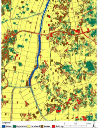
According to the officials of Commissioner and Directorate of Municipal Administration (CDMA), the municipal department, in collaboration with National Remote Sensing Centre (NSRC), has developed ‘Bhuvan Integrated Application’ by integrating all the properties in all Urban Local Bodies (ULBs) like property tax, water tax, trade license, advertisement tax, etc.
The aim was to increase the tax base without increasing the taxes through this application. The application helps in identifying the under-assessed or un-assessed properties with the help of satellite images. This will help the people to view their properties at one place without visiting the ULB office and avoiding human involvement. The ULB officials can also review the details without physically visiting the property. Around 4 lakh properties have been integrated till now with captured assessments.

